Here's a bird's eye view of Home Oaks Cemetery and Lakes Community High School. I wonder if some students from Lakes would like to do a community service project and map their cemetery online? This would be a great service and they could help solve some family mysteries right in their own backyard!
View Larger Map
Tuesday, December 30, 2008
Monday, December 29, 2008
A Cemetery at a High School?
Grave Mappers continues to receive information about cemeteries in interesting locations - backyards, highway interchanges, parking lots, and even at a high school!
Lakes Community High School is located in Lake Villa, Illinois. When students look out the windows here, they don't just see a football field. Home Oak Cemetery shares the same corner of the intersection with the high school, and students walk through it everyday to get to school! View a photo and read more about it at Lakes' student newspaper website. Also, in 2005, for his Eagle Scout Service Project, Boy Scout Cameron Bay photographed all of the headstones in this cemetery. You can view his photos here. Another great Eagle Scout Project would be to build on what Cameron has done and create a map of this cemetery on Names in Stone.
We've also found two more cemeteries in parking lots to add to our list:
Ver mapa más grande
This brings up a good question...
What if you want to map a cemetery on Names in Stone that is in a country other than the United States or Canada?
I contacted a Names in Stone representative and got some interesting information.
When you map a cemetery on the website, you create it on Google Maps. First, you register the name and address of the cemetery and then you are taken to the Google Map to pinpoint the location of the cemetery. As you know, these maps can take you anywhere in the world, and it's no different at Names in Stone. The website will allow you to map a cemetery at any location in the world.
Currently, the Cemetery List on the website only shows cemeteries in the United States and Canada. However, when cemeteries are added at other locations throughout the world, the website will be updated and will show the other countries as well. You can also contact Names in Stone at map@NamesInStone.com to let them know you are creating a map in another country.
Lakes Community High School is located in Lake Villa, Illinois. When students look out the windows here, they don't just see a football field. Home Oak Cemetery shares the same corner of the intersection with the high school, and students walk through it everyday to get to school! View a photo and read more about it at Lakes' student newspaper website. Also, in 2005, for his Eagle Scout Service Project, Boy Scout Cameron Bay photographed all of the headstones in this cemetery. You can view his photos here. Another great Eagle Scout Project would be to build on what Cameron has done and create a map of this cemetery on Names in Stone.
We've also found two more cemeteries in parking lots to add to our list:
- Louisville, Kentucky - near a McDonald's and a Hobby Lobby.
- Oviedo, Spain - in the parking lot of the Parque Principado Mall.
Anyone interested in creating online maps for these cemeteries?
Ver mapa más grande
This brings up a good question...
What if you want to map a cemetery on Names in Stone that is in a country other than the United States or Canada?
I contacted a Names in Stone representative and got some interesting information.
When you map a cemetery on the website, you create it on Google Maps. First, you register the name and address of the cemetery and then you are taken to the Google Map to pinpoint the location of the cemetery. As you know, these maps can take you anywhere in the world, and it's no different at Names in Stone. The website will allow you to map a cemetery at any location in the world.
Currently, the Cemetery List on the website only shows cemeteries in the United States and Canada. However, when cemeteries are added at other locations throughout the world, the website will be updated and will show the other countries as well. You can also contact Names in Stone at map@NamesInStone.com to let them know you are creating a map in another country.
Thursday, December 18, 2008

Wednesday, December 17, 2008
One Good Reason to Map Cemeteries
Here's a video that speaks for itself - another great reason to get our cemeteries mapped on Names in Stone!
Ike Scatters Caskets - Watch it on YouTube
Ike Scatters Caskets - Watch it on YouTube
Tuesday, December 16, 2008
Abandoned Cemeteries in Hanceville, Alabama
An anonymous reader sent Grave Mappers the coordinates and locations for three abandoned cemeteries in Hanceville, Alabama and another cemetery in Cullman County:
- In someone's yard, next to their house - 34o 03'55.58" N 86o 45'30.65" W elev 541 ft.
- A small patch of trees contains a graveyard between Interstate 65 and Highway 31 in Alabama: 34o 18'49.39" N 86o 54'06.05" W elev 630 ft.
- Another adjacent to an apartment complex in Hanceville Alabama: 34o 04' 08.89" N 86o 46' 18.42" W elev. 555 ft.
- The Boyd Cemetery in Cullman County hidden by a path of trees: 34o 04'27.65" N 860 46' 28.31" W elev 608 ft.
Check Out These Cemeteries in Strange Places!
Here is a list of even more cemeteries in parking lots and other strange places from readers of Wesley Treat's Roadside Resort:
I found more information about the cemetery at Starbucks in Virginia from Interment.net: It's the Thompson Family Cemetery, Lee Hwy (Rte 29) east of Nutley Rd in Fairfax, Virginia at the entrance to the Pan Am Shopping Center. There are two visible headstones, but this site includes a list of additional burials.
To get these cemeteries mapped at Names in Stone, all we need is a descriptive location of the cemetery, headstone locations in relationship to other headstones, and the headstone information. At NIS, you find the cemetery on a Google Map - if you already have the coordinates or location, it's especially easy - you just enter the location and you're on your way!
- Monroe, Michigan - behind a strip mall, between S. Monroe St. to the East and Harrison to the West, and Merkle to the South and W. 8th St. to the North.
- Summerville, South Carolina - on US-17, in between lanes entering a Walmart Plaza, next to Hardees.
- Fairfax/Vienna, Virginia - at the corner of Lee Hwy. and Nutley St. near a Safeway and a Starbucks.
- Memphis, Tennessee - next to the Piggly Wiggly.
- Austin, Texas - in the middle of a highway exchange.
I found more information about the cemetery at Starbucks in Virginia from Interment.net: It's the Thompson Family Cemetery, Lee Hwy (Rte 29) east of Nutley Rd in Fairfax, Virginia at the entrance to the Pan Am Shopping Center. There are two visible headstones, but this site includes a list of additional burials.
To get these cemeteries mapped at Names in Stone, all we need is a descriptive location of the cemetery, headstone locations in relationship to other headstones, and the headstone information. At NIS, you find the cemetery on a Google Map - if you already have the coordinates or location, it's especially easy - you just enter the location and you're on your way!
Recently Added to Names in Stone: Huntington Rural Cemetery, Huntington, New York
The Huntington Rural Cemetery in Huntington, New York was recently added to the Names in Stone website. It is located at 555 New York Avenue between New York Avenue and Oakwood Roads.
This cemetery has an interesting history. In the early 1800's, cemeteries in cities were running out of space. It was not uncommon to have bodies removed so that others could be buried! Thus began the rural cemetery movement. Early in the movement, cemeteries weren't just burial spots - they were used as parks as well! Huntington Rural was established in 1851, and apparently it was greatly needed....
From the Huntington Rural Cemetery website:
"In an editorial dated February 28, 1851, The Long-Islander urged the establishment of a new cemetery lamenting "We have almost fancied whilst passing the present burial place (the Old Burying Ground), and seen the bones of those who have been deposited there, sacrilegiously thrown out and exposed to make room for others, that we could hear a low murmur of reproach against those who 'permit such things' and witness an involuntary compression of those lying near, that they might escape the ruthless spade. Surely there should be peace in the possession of 'God's Acre.'"
From its beginning, the cemetery has admitted burials of all persons regardless of race, nationality, creed, or economic status, even before this was a common practice. Notable people buried at Huntington Rural:
Click here to see a photo of his headstone - his epitaph is a quotation from his song, "I Wonder What Would Happen to this World" - 'Oh if a man tried to take his time on earth, and prove before he died, what one man's life could be worth, I wonder what would happen to this world.'
Here's Harry Chapin's grave on the map at Names in Stone.

This cemetery has an interesting history. In the early 1800's, cemeteries in cities were running out of space. It was not uncommon to have bodies removed so that others could be buried! Thus began the rural cemetery movement. Early in the movement, cemeteries weren't just burial spots - they were used as parks as well! Huntington Rural was established in 1851, and apparently it was greatly needed....
From the Huntington Rural Cemetery website:
"In an editorial dated February 28, 1851, The Long-Islander urged the establishment of a new cemetery lamenting "We have almost fancied whilst passing the present burial place (the Old Burying Ground), and seen the bones of those who have been deposited there, sacrilegiously thrown out and exposed to make room for others, that we could hear a low murmur of reproach against those who 'permit such things' and witness an involuntary compression of those lying near, that they might escape the ruthless spade. Surely there should be peace in the possession of 'God's Acre.'"
From its beginning, the cemetery has admitted burials of all persons regardless of race, nationality, creed, or economic status, even before this was a common practice. Notable people buried at Huntington Rural:
- Harry Chapin, popular singer and songwriter, who was killed in 1981 on the Long Island Expressway
- 176 Civil War veterans
- Abner Crossman, (memorial stone) soldier of the American Revolution
- The Browns of Brown Brothers Pottery fame
- Dr. Walter Lindsay, noted Civil War doctor
- Samuel Ballton, African-American Civil War veteran and former slave, who died in 1917 - he was known as the "Pickle King" for his skill in growing cucumbers for the pickle industry.
Click here to see a photo of his headstone - his epitaph is a quotation from his song, "I Wonder What Would Happen to this World" - 'Oh if a man tried to take his time on earth, and prove before he died, what one man's life could be worth, I wonder what would happen to this world.'
Here's Harry Chapin's grave on the map at Names in Stone.

Monday, December 15, 2008
Names in Stone Features - Search for a Grave

One of the great features of Names in Stone is being able to search for specific people in the multi-cemetery database.
I did a search this morning for my grandparents who are buried in the Logan, Utah cemetery. I just entered their last name - Gunnell - and selected the cemetery they were buried in. I could also have entered more specific information about them and refined my search, but I found the information I wanted on my first try.
These are my search results.

Next, I clicked the map button next to Hazel. This took me to the map page, where I can see both Hazel and Joshua buried next to each other. I can also see what information the cemetery has on both Hazel and Joshua.

After viewing the cemetery record, I clicked on Source: Community. This is a page where anyone can add additional information about the deceased person. For instance, on Hazel's page, someone has entered her spouse's name because it wasn't part of the original cemetery record. They have also added a photo of Hazel and her daughters taken in 1945.

I have a great photo of Hazel and her husband taken in 1920. I decided to add that photo to Hazel's grave record. I first clicked "Edit Info." Then I clicked on "Upload Image." That took me to this window - I can browse my computer and find the photo I want to use; give it a title; select what kind of image it is (my choices are headstone, photo, obituary, history, or other); and finally, upload the image.

This is Hazel's community window now that I have added my photo! You can also click on the photo and see a large version on your screen with the title below it.

All Names in Stone screenshots used by permission. Click on a screenshot for a closer view.
Thursday, December 11, 2008
Nashville Family Cemeteries
Small family cemeteries are particularly abundant in the southern part of the United States. And the Nashville area is no exception!
In 2006, Theo Emery wrote an article for WashingtonPost.com called "More Family Cemeteries Dying Away in the South."
He says: "In Tennessee, as in other Southern states, farm families in centuries past tended to bury their dead on their own land, allowing for quick interment and easy oversight of graves. In the Northeast, by contrast, families were more likely to use public burial grounds and church cemeteries.
"The Southern pattern was that every farm or plantation would have their family cemetery," said Charles Reagan Wilson, director of the Center for the Study of Southern Culture at the University of Mississippi.
"State archaeologist Nick Fielder estimates that there are 20,000 family cemeteries in Tennessee, but there's no way to know for sure. There's no central inventory, and most documentation is done by historians and volunteers who scour records and trudge through meadows in search of graves."
Just a few of the Nashville area family cemeteries were referred to in the article:- Mount Juliet - A tiny family cemetery is in the middle of the Nashville Auto Auction parking lot.
- Nashville, Tennessee - At the Nashville Zoo at Grassmere, there is a historic plantation house and a cemetery with graves dating back to the 1700's.
- North of Nashville - A cemetery is tucked in a highway cloverleaf.
- South of Nashville - A family cemetery is on the grounds of a hotel, next to a parking lot.
- Nashville - The Hardgrave Family Cemetery is located on a hill overlooking the Harpeth River. It is just south of Percy Warner Park across the county line into Williamson County in the Horseshoe Bend subdivision.
- Near Athens - Cate Family Cemetery, near a residence on Road #262 in McMinn County.
- Nolensville - Hailey Family Cemetery, Williamson County, intersection of Kidd Road and Baronswood Drive.
- Lascossas - Mount Family Cemetery, 25 graves located in Wilson County on Spain Road.
Wednesday, December 10, 2008
Question of the Day: What about large cemeteries?

Question: My city cemetery is not on Names in Stone, but it is too large for me to map myself. How do we get large cemeteries into the database?
Answer: At Names in Stone, there are two classifications of cemeteries - Class A and Class B.
Class A - Cemeteries that are managed by a public agency such as a city, county, cemetery district, or a private entity such as a funeral home or church. They are usually well over 200 graves and are mapped by the managing organization.
If you know of a Class A cemetery you would like added to Names in Stone, contact the management of the cemetery and inform them of the website. You can encourage them to complete a Cemetery Questionnaire, and then they can fax it to Names in Stone. A NAMES IN STONE representative will contact them with pricing and funding suggestions for having their cemetery digitally mapped. (The Questionnaire and Fax # are available in the 'Map a Cemetery' section of the website.) Cemetery membership in Names in Stone is free.
Class B - Small cemeteries, usually less than 200 graves, that are often cared for by families or volunteers. These are the cemeteries that we as Grave Mappers can add to the database. These include abandoned cemeteries, family cemeteries, small town cemeteries, and any small cemeteries that are not mapped by a managing organization.
Tuesday, December 9, 2008
More Parking Lot Cemeteries
Thanks to the Grave Mappers who are busy mapping Parking Lot Cemeteries!
Here are a few more...
Do we have any Grave Mappers in Ohio, Alabama, or North Carolina?
I wonder if you Wolfpack fans knew you were parking your cars right next to two cemeteries!
View Larger Map
Here are a few more...
Do we have any Grave Mappers in Ohio, Alabama, or North Carolina?
- Cemetery (4 graves or so) in the parking lot of the Regal Cinemas – Middleburg Heights, Ohio
- Cemetery in front of a Burlington Coat Factory store and the shopping center entrance off of University and Rideout Drive – Huntsville, Alabama
- Two cemeteries at Carter-Finley Stadium, North Carolina State University – Raleigh, North Carolina. Cemetery #1: In a grove of trees in the center of the parking lot behind Parking Space #93034B. Cemetery #2: Towards the stadium and slightly to the right in a wooded area, four headstones are visible in front of Parking Space #00589.
I wonder if you Wolfpack fans knew you were parking your cars right next to two cemeteries!
View Larger Map
Monday, December 8, 2008
Location, Location, Location...
Here's another cemetery in a strange location:
View Larger Map
View Larger Map
It's located at the north-western edge of Toronto, Ontario, Canada - at the junction of Highway 427 and Highway 401, one of the busiest highways in North America.
Call-out to Toronto Grave Mappers --- Is there someone who could get to this cemetery to map it? We'd love to get these records into the Names in Stone database!
Does anyone have any information about this freeway cemetery and its occupants? Email us at gravemappers@gmail.com and we'll share the story!
Parking Lot Cemeteries
Remember Mary Ellis' grave that's located in a movie theater parking lot? (see blog entry - November 26) Well, she's not the only one! Come to find out, there are cemeteries located in parking lots all over the country!
I found a list of some of them at Wesley Treat's Roadside Resort. Visit the website for cemetery photos and read some great stories and legends, too.
- Tullahassee Creek Indian Cemetery – Sand Springs, Oklahoma
- Burr Cemetery – Commack, New York
- Bettis Family Cemetery – Memphis, Tennessee
- Mystery Cemetery – Warner Robins, Georgia
- Crowley Mausoleum – Decatur, Georgia
- Family cemetery at Yorktown Mall – Lombard, Illinois
- Ayres Cemetery, motel parking lot, 2500 Block of Scott Street – Fort Worth, Texas
- Cemetery in front of liquor store and Giant grocery store – Gainesville, Virginia
- Cemetery at the Carolina Mall – Concord, North Carolina
- Cemetery in front of the Cinemark – Mansfield, Texas
- Cemetery at the Palisades Mall – West Nyack, New York
- Gash Cemetery at Metro North Mall – Kansas City, Missouri
- Cemetery on the edge of a strip mall center along Route 157 – Edwardsville, Illinois
- Henderson Family Cemetery – Lilburn, Georgia
- Melvin-Lewis Cemetery off Parker Road and Orchard Road – Aurora, Colorado
Many times, these small cemeteries do not have official records or caretakers. The only records they have are their headstones. Wouldn't it be great if we could help preserve these cemeteries and make their records available for research?
Does anyone live near these Parking Lot Cemeteries? Grave Mappers is asking for your help! Let's get these cemeteries mapped on Names in Stone!
If you have access to the cemeteries, but are unable to do the mapping, let us know. We'll be glad to help! Also, if you know about other parking lot cemeteries, we'll add them to our list. Just contact us at gravemappers@gmail.com.
Sunday, December 7, 2008
Eagle Scout Project - Leader Message
Grave Mappers received this message from one of the leaders who accompanied the Boy Scouts as they mapped the Fairfield, Utah Cemetery.
"I was impressed with this group of scouts as they mapped the Fairfield, Utah Cemetery. They worked very hard for several hours mapping, photographing, and transcribin g information from headstones.
 g information from headstones.
"It was intriguing to watch them. They came to support their friend, but most of them had no previous experience with cemeteries. As they worked, they became curious and then interested in the cemetery and its occupants. I saw some of them bent over, reading monuments and headstones. They wondered  about headstones that had many small items around them left by family and friends. They were touched by three headstones right in a row that said, "Killed by Indians." Sometimes they tried to piece together family relationships by seeing the burials that were next to each other. I've included a few photos of things that peaked their interest.
 about headstones that had many small items around them left by family and friends. They were touched by three headstones right in a row that said, "Killed by Indians." Sometimes they tried to piece together family relationships by seeing the burials that were next to each other. I've included a few photos of things that peaked their interest.
Wednesday, December 3, 2008
Eagle Scout Service Project: Map a Cemetery
 As many of you know, to earn the rank of Eagle Scout, a Boy Scout has to do a service/leadership project that totals 80 to 150 hours.
Adam D. of American Fork, Utah decided that for his service project, he would map the Fairfield, Utah cemetery. Adam's plan was to lead a group of Scouts in transcribing headstone information, mapping the nearly 300-grave cemetery, photographing each headstone, and then creating an online map of the cemetery at Names in Stone.

Early in November, Adam recruited 6 other scouts and two leaders who made the trip to Fairfield, located west of Utah Lake in Utah County. Adam split the group into three teams and held a brief training exercise to make sure the Scouts knew their goals and responsibilities. Each team had a photographer, a mapper, and a recorder. They divided the cemetery into three sections and the teams went to work.
Adam's scout committee whole
 heartedly approved his project and are excited about his choice to map a cemetery. They are encouraging other scouts to consider mapping a cemetery for their Eagle Projects.
Adam says that the first phase of the project at the cemetery was a great success and he is currently creating the cemetery map on the NAMES IN STONE website. Adam has some great ideas for other Boy Scouts who might be interested in mapping a cemetery for their Eagle Scout Service Projects.
Cemetery tips:

- Use graph paper to draw the cemetery map. With several scouts drawing maps, it can be hard to keep things consistent. Graphing paper helps the mappers keep things lined up and in order. It also helps the person creating the map on the website be more accurate in placing graves.
- Make sure that the mapper, photographer, and recorder stay together and map one grave at a time. If someone goes ahead things get confusing and people make mistakes.
- Use string, or some other kind of marker, to make a dividing line in the cemetery so the teams don't overlap.
- Periodically check quality and accuracy of each team's work - make sure everyone is using the same system and that there are no misunderstandings or mistakes.
Mapping tips:
- Divide the hand-drawn map into several sections. Place graves for a whole section at a time and then go back and enter the data for each grave.
- Upload each headstone photo at the same time you enter the record.
- Use two person teams to enter the records. One person can enter the data and the other person can check for accuracy of the written record compared to the headstone and make sure the computer entry is correct.


Adam and his friends really enjoyed mapping this cemetery. Adam says, "I had the feeling that we were helping the descendants of the people who are buried here find their ancestors. I know that what we're doing will help keep their memory alive."
Wednesday, November 26, 2008
One Grave Cemeteries
There are two unique cemeteries new to the Names in Stone database. What's so different about them? Each of them only has one grave!
The Mary Ellis Grave is located in a movie theater parking lot in New Brunswick, NJ! You can be sure that when Mary Ellis came to live in this beautiful setting by the Raritan River that there was no parking lot around! Legend has it that she came in the 1790's to stay with her younger sister Margaret. She fell in love with a sea captain, who promised that when he returned they would be married. She waited, and waited......Read all of her tragic story -- and find out why her grave is located in a parking lot -- at Weird N.J.'s travel guide.
The Lone Grave Cemetery is located in Dewhurst, Wisconsin. This is the burial site of Blanche Grimes, a 16 month old baby. She was the daughter of Frank and Emma Grimes, born April 1, 1894 and died August 5, 1895. In the 1890's, a little town called Columbia sprang up here, with at least twenty stores, a schoolhouse, and a depot. But by 1910, most of the settlers had gone. One of these families was Frank and Emma Grimes, who had to leave behind the grave of their baby daughter. Now all that's left is a log cabin and a grave. It is actually believed that there are 27 graves in this little cemetery, but only one grave marker. Go to the Clark County, Wisconsin Internet Library ALHN & AHGP website to see photos and learn more about the history of Lone Grave Cemetery.
Does anyone know of other cemeteries with only one grave? Contact us at Grave Mappers and we'll share their stories.
Do you live near any of these small cemeteries? We need your help mapping! Let's get these One Grave Cemeteries on Names in Stone so we can preserve their records!
Monday, November 24, 2008
Mapping Hint - Explorer or Firefox?
I have mapped cemeteries on Names in Stone in both Internet Explorer and Firefox and here's what I've found.
- I like mapping cemeteries on Firefox much better than Explorer. The graves are uniformly shaped and sized and you can zoom in extremely close up to get a very good placement of the graves. One thing to note however: You need to use the updated version of Firefox - version 3.0.4. Just make sure you get your free Firefox upgrade!
- When you use Explorer the map looks a bit odd. The graves are different sizes and shapes, and you can't zoom in as closely as you would like. (I talked with the website developer and they said it is a browser problem that they are working on.)
Sunday, November 23, 2008
Decorate a Grave
Have you seen the Decorate a Grave feature on Names in Stone?

What a wonderful way to honor those who have passed on! You can upload a photo of a headstone and then decorate it with creative flower arrangements, holiday decorations, and other images.
I decorated a family member's grave and it was very enjoyable -- and it looks lovely! You can view your decorations when you select the grave, and the decor stays on the grave for three months.
Here's some hints about decorating a grave:
- If you have a headstone photo, first upload it on the Community Page. Then click on "Decorate." Your headstone photo can be found under Community Images on the right side of your screen. Just drag it across to the left side of your screen on top of the headstone example.
- Don't have a headstone photo? Select one from the headstone section on the right of your screen. Drag it across, then add the name and dates in whatever text and color you like!
- Now drag flowers or other images across to decorate the grave. You can resize these images by clicking on one of the colored squares around the selected image and then dragging it to change the size. You can also change the direction the image is facing by dragging these squares.
Thursday, November 20, 2008
Where is my Unfinished Cemetery?
Question of the Day:
I wasn't able to finish mapping my cemetery in one sitting. When I went back to Names in Stone, I couldn't figure out how to get back into it to finish mapping. How do I find my cemetery?
Answer: There are two ways to find your cemetery to continue mapping.
I wasn't able to finish mapping my cemetery in one sitting. When I went back to Names in Stone, I couldn't figure out how to get back into it to finish mapping. How do I find my cemetery?
Answer: There are two ways to find your cemetery to continue mapping.
- After signing in to Names in Stone, click on the Membership Box and select "My Profile." On your profile page above your personal information are several green tabs. Select "Cemetery Projects." This will give you a list of the cemeteries you are working on. Click "Work on Cemetery" and you'll be ready to begin mapping!
- After signing in to Names in Stone, select "Cemetery List." Select the state where your cemetery resides. Find your cemetery and click "More Details." You will again see the button "Work on Cemetery." Click on it and begin mapping!
Tuesday, November 18, 2008
Adding Photos
A great feature that I like about Names in Stone is the Community Forum.

Here you can add your own information to a grave record. For instance, if you have additional dates or places that aren't on the cemetery record, you can add them here. You can add photos or other digital images - like headstone photos or family photos.
You can also participate in discussions or ask for research help on the Discussion page. This would be a great place to link up with other people who are researching the same records you are!
This is a great addition - I particularly like adding headstone photos to the graves. I like being able to access the headstone when I'm looking at the grave record. What a great research tool!
You can add headstone photos to graves in cemeteries that are already in the database or add them to your own maps. You can also find your relatives in any cemetery and add their family photos to their records.
You reach this page on the website in a couple of different ways:

Here you can add your own information to a grave record. For instance, if you have additional dates or places that aren't on the cemetery record, you can add them here. You can add photos or other digital images - like headstone photos or family photos.
You can also participate in discussions or ask for research help on the Discussion page. This would be a great place to link up with other people who are researching the same records you are!
This is a great addition - I particularly like adding headstone photos to the graves. I like being able to
 access the headstone when I'm looking at the grave record. What a great research tool!
You can add headstone photos to graves in cemeteries that are already in the database or add them to your own maps. You can also find your relatives in any cemetery and add their family photos to their records.
You reach this page on the website in a couple of different ways:
- Search for a deceased person - Smith, Mary. On the home page enter the name on the right under "Searching Maps." This will take you to the results of your search. Find "Smith, Mary" in your results list. Under her record you will find some options: Map, Community, Add to List, Decorate. Click on "Community." This will show you other information that visitors other than the cemetery itself have contributed to Mary Smith's record.
- Search for a cemetery. On the home pagean the cemetery have contributed about this person., select "Cemetery List." Click on the state where your cemetery resides and then select your cemetery from that list. Now select a grave within the cemetery. On the right you will find three tabs - Source: Cemetery, Source: Community, Discussion. Click on "Source: Community." This will show you other information that visitors other th
Sunday, November 16, 2008
Mapping the Mendenhall Family Cemetery - part 2
Mapping this cemetery was so easy!
Here's some things I learned that might help you as you map your cemeteries.
Note: Names in Stone mapping screenshot used by permission.

Here's some things I learned that might help you as you map your cemeteries.
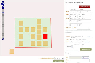
- You first draw the outer boundaries for the cemetery. Select "Draw Cemetery Border." Click to place each corner and then double click when the border is complete. I had to try a few times to get it just right (only because I'm very picky!) I just clicked "Draw" again and it erased the old border, so I could start again.
- Use "Place Graves" to add each grave. Just select "Place" and then click on the map where you want to put each grave. A square that represents a 4'x4' grave appears on the map. After you place a grave, enter the grave's record information in the data fields to the right. If you have family information like parents, click on the drop-down menu arrow beside "Spouse". Here you select from spouse, father, mother, and other. Enter the name and then click "Add Relation." You can add as many relations as you want - just click "Add Relation" after each one.
- Make sure you select "Save Deceased" after every grave.
- If you don't like where you placed a grave, click on "Move Graves." Then you can click on the grave and put it anywhere you like.
- If you need to delete a grave, just select "Delete Graves" and click on the grave you want to erase.
- You can still redraw your border even after you place the graves. I found that my border was way too big once my graves were all placed. Just click on "Draw Cemetery Border." It will erase the previous border without erasing your graves and data, and you can draw a new border around your graves.
- Navigating around the cemetery can be a little tricky until you get used to it. Don't use the scroll wheel on your mouse while your cursor is over the map - unless you want to zoom in or out! You can navigate with your mouse or with the map tools in the upper left corner of the map.
Note: Names in Stone mapping screenshot used by permission.
Saturday, November 15, 2008
Mapping the Mendenhall Family Cemetery
I recently mapped a small family cemetery on Names in Stone. The Mendenhall Family Cemetery is near Dayton, Idaho. It is a family tradition to visit this cemetery and hear the stories of Grandpa George Mendenhall, Grandma Celestia Mendenhall, and all the children they lost in the diptheria epidemic. George and Celestia Mendenhall are buried in this cemetery, along with George's father Thomas, several of their children, and an unnamed wagon train child.
I am excited to have the cemetery on this website because I love the whole concept of being able to access the records just by clicking on a grave, and I like the idea of making the records available for others to search as well. I created my map from a drawing my dad made when he visited the cemetery last summer.
I am excited to have the cemetery on this website because I love the whole concept of being able to access the records just by clicking on a grave, and I like the idea of making the records available for others to search as well. I created my map from a drawing my dad made when he visited the cemetery last summer.

First, I registered for a free (free is nice!) membership at Names in Stone. Then I clicked on "Learn More" under "Map a Cemetery." This took me to a description of Class A and Class B Cemeteries. Class A cemeteries are large cemeteries that are usually maintained by a public or private agency. Class B cemeteries are smaller cemeteries that are cared for by families or volunteers. My cemetery only has about 15 graves, so I clicked on Class B - "Add a Cemetery."
The next step is to fill out the "Cemetery Project Application." I didn't have an exact address, so I just gave a good description of the location in the address field. At the bottom of the application is a Google Map. On the map, I found the approximate area in Idaho. I pressed the Shift key and with my mouse drew a square around that area. I was worried about being able to find it on the map, but it zoomed right in to that area and worked really well. I compared my dad's drawing to the Google Map and using roads and a canal, I was able to pinpoint exactly where the cemetery is.
At Names in Stone they say that if your cemetery is in an inhabited area, you'll be able zoom in close enough to see the cemetery and maybe even the headstones. My cemetery is in a rural area and I couldn't zoom in that closely, but they say that the goal is not exact measurements - what's important is showing the graves in relation to each other.
Mapping the Mendenhall Family Cemetery....to be continued tomorrow
Wednesday, November 12, 2008
Welcome to GRAVE MAPPERS!
Everyone who visits cemeteries knows that the priceless information on headstones is not permanent. These headstones are very vulnerable to the effects of weather, time, and even vandalism. For many small cemeteries, headstones are their only records. That's why genealogists, historians, and hobbyists have spent countless hours transcribing information from headstones and monuments throughout the world. They know how critical it is to save that information in a safe, permanent place.
At Grave Mappers, we are committed to this effort. And we are excited about the launch of a new website called NAMES IN STONE.
NAMES IN STONE is a different kind of online cemetery repository. Not only is it a growing collection of cemetery maps, but it's a place where anyone and everyone can create a cemetery map—a map that has the records of each grave attached right to it! To access grave records on these interactive maps, you just click on the grave and the information pops up on your screen. You can link headstone photos and other digital images to the graves. And on the community forum, you and others can add information about the cemetery and the people who are buried there.
We invite you to join Grave Mappers and help us in this exciting new project: creating online interactive cemetery maps! Together we can document these aging cemeteries and headstones, preserve their records permanently, and share them with the world!
Grave Mappers wants to hear your experiences as you map cemeteries at NAMES IN STONE. Please share your stories and photos with us and we'll include them in our blog so you can inspire others in their mapping quest. Contact us at:

Subscribe to:
Posts (Atom)


